

Mapping Your Watershed: How to Pinpoint Nutrient Sources
 |

Summary:
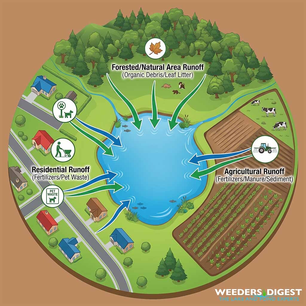
Identifying where excess nutrients come from is the most critical step in managing your lake or pond’s health. To understand your water quality, you must first distinguish between "point source" pollution—which comes from a single, traceable location like a pipe or discharge point—and "non-point source" pollution, which enters the water from broad, diffuse areas across the landscape. Most of the nutrients fueling algae blooms and excessive weed growth in private lakes and ponds fall into the non-point category, arriving via rain and snowmelt runoff that carries fertilizers, pet waste, organic debris, and sediment from your entire surrounding drainage basin.
In my years of field experience as a Certified Lake Manager, I have frequently walked properties where landowners were baffled by recurring algae blooms, only to discover a "hidden" contributor—such as a poorly maintained drainage ditch or a lawn that was being fertilized right up to the water’s edge. Often, we find that what a landowner perceives as a lake problem is actually a watershed management problem. By mapping your watershed, you transition from reactive "weed fighting" to proactive water quality stewardship, allowing you to intercept these nutrient pathways before they ever reach your waterbody.
The Science Behind It:
The fundamental challenge in watershed management is the movement of limiting nutrients—specifically nitrogen and phosphorus—from the terrestrial environment into the aquatic ecosystem. Phosphorus is typically the primary limiting nutrient in freshwater systems, meaning its concentration dictates the productivity of the lake. When excess phosphorus enters the system, it triggers eutrophication, a process where primary production (algal and plant biomass) increases to levels the ecosystem cannot support. As these plants die and decompose, microbial activity spikes, which rapidly consumes dissolved oxygen, often resulting in hypoxic or "dead" zones that are detrimental to fish and invertebrate populations.
To quantify these impacts, scientific research utilizes models like the SPARROW (SPAtially Referenced Regressions On Watersheds) model, which links in-stream water quality measurements to specific landscape attributes and source inputs. According to research published by the U.S. Geological Survey and widely utilized in ecological management, these models have shown that non-point source pollution is the leading cause of water quality impairment in the nation's waterbodies. Specifically, data suggests that approximately 80% of lakes and reservoirs are impacted by these diffuse, non-point sources.
The pathway for this pollution is primarily hydrologic. As rain or snowmelt traverses the landscape, it acts as a conveyor belt for pollutants. The mass-balance approach to watershed nutrient tracking involves comparing total source inputs—such as agricultural fertilizer, residential landscape runoff, and atmospheric deposition—against the outputs observed in water samples. Researchers have documented that the "lag time" between land-use changes and the observable response in a lake can vary significantly based on soil permeability, slope, and groundwater interaction. In studies analyzing nutrient concentrations, mean annual phosphorus levels are frequently used as a diagnostic metric to determine the severity of watershed loading, with even minor increases in mg/L concentrations having significant biological repercussions for lake transparency and habitat quality.
Effective watershed mapping requires a multi-scale analysis. At the macro level, professionals use Geographic Information Systems (GIS) to delineate the catchment area—the specific land area that drains into your lake. At the micro level, field technicians perform site surveys to identify "critical source areas" where high-nutrient runoff is most likely to concentrate. By calculating the total load from these specific sub-catchments, managers can implement Best Management Practices (BMPs), such as vegetative buffer strips or bioswales, which effectively intercept and trap nutrients before they undergo internal cycling within the lake.