


My Shoreline, My Boundary: Understanding Your Lake’s High Water Mark
 |

Summary:
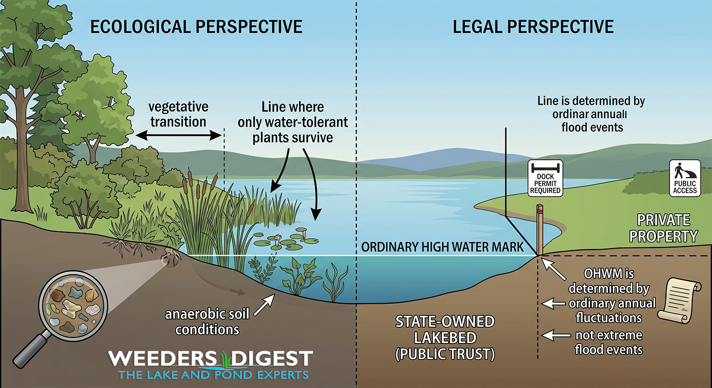
Have you ever noticed a distinct line on your rocks or a point where the lush grass suddenly gives way to aquatic plants? That isn't just a mark left by a rainy season; it is likely the Ordinary High Water Mark (OHWM). For anyone lucky enough to own waterfront property, understanding this line is essential because it serves as the legal and biological boundary between your private backyard and the public waters. It is the pulse of the lake, representing the highest level the water reaches under normal conditions without including extreme, one-off flood events.
Determining where your land ends and the lake begins can be tricky, especially as water levels naturally rise and fall throughout the year. The OHWM isn't necessarily where the water is sitting today; rather, it is a physical "scar" on the landscape carved by the water’s persistent presence over time. It is often identified by changes in soil, the types of vegetation growing there, or even staining on permanent structures like bridge abutments or boulders.
Knowing where this line sits on your property is about more than just curiosity—it’s about stewardship and compliance. Most regulations regarding docks, shoreline restorations, or beach sanding are tied directly to this mark. By respecting this boundary, you help protect the delicate transition zone that keeps the water clean and provides a home for local wildlife.
The Science Behind It:
The Ordinary High Water Mark (OHWM) is a multi-dimensional concept defined by the intersection of hydrology, geomorphology, and biology. According to the U.S. Army Corps of Engineers (USACE), the OHWM is characterized by "the fluctuations of water as indicated by physical characteristics such as a clear, natural line impressed on the bank; shelving; changes in the character of soil; destruction of terrestrial vegetation; the presence of litter and debris; or other appropriate means that consider the characteristics of the surrounding areas." This line represents the limit of the water's influence on the terrestrial environment, marking a transition from upland ecosystems to aquatic or wetland systems.
Hydrologically, the OHWM is not determined by the absolute peak flow of a rare flood event (such as a 100-year flood) but rather by the "ordinary" annual fluctuations. Research published through University Extension programs emphasizes that the OHWM is established by the presence of water for a sufficient period to leave a distinct mark upon the landscape. This duration of inundation must be long enough to shift the soil chemistry from aerobic to anaerobic conditions, which in turn dictates the survival of specific plant species. The physical evidence of this process includes "water staining," where dissolved minerals like iron and manganese precipitate onto rocks and structures, leaving a visible "bathtub ring" that persists even during droughts.
Biologically, the OHWM is often identified through the "vegetative transition." Terrestrial plants, such as upland grasses and certain hardwood trees, cannot survive prolonged root submersion and will cease to grow below this line. Conversely, hydrophytic vegetation—plants adapted to saturated soils—flourish at or below the OHWM. Ecologists use the presence of these "obligate" and "facultative" wetland species to map the boundary with high precision. This transition zone is ecologically critical, acting as a riparian buffer that filters nutrient runoff, such as phosphorus and nitrogen, before they enter the basin and contribute to eutrophication.
From a management perspective, the OHWM is the jurisdictional "point of beginning" for regulatory oversight. In many North American jurisdictions, the area lakeward of the OHWM is held in the public trust, meaning the state or province manages the lakebed for the benefit of the public. Consequently, any anthropogenic modifications—such as the installation of rip-rap for erosion control or the removal of aquatic macrophytes—are subject to permitting based on their proximity to this line. Understanding the OHWM is therefore fundamental to both limnological research and the legal framework of water resource management.